|
|
| Point ID: 5092 | Downloads | Plots | Site Data | Code: 03BB001 |
|
| Download | |
|---|---|
| Site Descriptor Information | Site Time Series Data |
| Link to all available data | |
|
|
|
| View: | Statistics | All |
| Units: | m3/s |
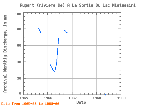
| Year | Jan | Feb | Mar | Apr | May | Jun | Jul | Aug | Sep | Oct | Nov | Dec | Annual | 1965 | 83.45 | 76.04 | 1966 | 33.97 | 31.81 | 28.07 | 38.02 | 68.45 | 78.19 | 77.97 | 1968 | 58.86 |
|---|
 Return to R-Arctic Net Home Page