|
|
|||||||||||||||||
| Point ID: 5090 | Downloads | Plots | Site Data | Code: 03AD001 |
|
|
|||||||||||||||||
| Download | |
|---|---|
| Site Descriptor Information | Site Time Series Data |
| Link to all available data | |
| View: | Time Series | All |
| Units: | m3/s |
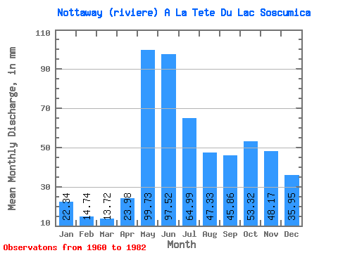
| Statistic | Jan | Feb | Mar | Apr | May | Jun | Jul | Aug | Sep | Oct | Nov | Dec | Annual |
|---|---|---|---|---|---|---|---|---|---|---|---|---|---|
| Mean | 22.33 | 14.87 | 13.72 | 23.98 | 99.71 | 97.52 | 64.98 | 47.32 | 45.86 | 53.31 | 48.17 | 35.94 | 566.51 |
| Standard Deviation | 5.40 | 2.70 | 3.31 | 14.07 | 23.60 | 30.17 | 17.69 | 11.64 | 14.40 | 15.97 | 15.98 | 13.15 | 92.17 |
| Min | 13.79 | 10.06 | 8.85 | 8.25 | 62.41 | 53.19 | 41.87 | 24.78 | 19.88 | 26.69 | 24.34 | 19.79 | 414.12 |
| Max | 38.70 | 21.00 | 26.13 | 64.01 | 154.62 | 200.60 | 108.52 | 66.14 | 75.73 | 79.64 | 79.34 | 73.59 | 781.59 |
| Coefficient of Variation | 0.24 | 0.18 | 0.24 | 0.59 | 0.24 | 0.31 | 0.27 | 0.25 | 0.31 | 0.30 | 0.33 | 0.37 | 0.16 |
 Return to R-Arctic Net Home Page