|
|
|||||||||||||||||
| Point ID: 5090 | Downloads | Plots | Site Data | Code: 03AD001 |
|
|
|||||||||||||||||
| Download | |
|---|---|
| Site Descriptor Information | Site Time Series Data |
| Link to all available data | |
| View: | Time Series | All |
| Units: | mm |
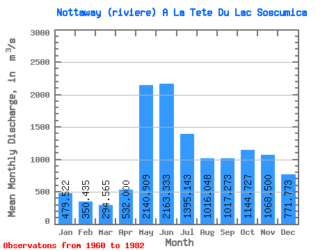
| Statistic | Jan | Feb | Mar | Apr | May | Jun | Jul | Aug | Sep | Oct | Nov | Dec | Annual |
|---|---|---|---|---|---|---|---|---|---|---|---|---|---|
| Mean | 479.52 | 350.44 | 294.56 | 532.00 | 2140.91 | 2163.33 | 1395.14 | 1016.05 | 1017.27 | 1144.73 | 1068.50 | 771.77 | 1032.14 |
| Standard Deviation | 115.96 | 63.68 | 71.07 | 312.04 | 506.65 | 669.20 | 379.84 | 249.88 | 319.37 | 342.88 | 354.40 | 282.37 | 167.92 |
| Min | 296.00 | 237.00 | 190.00 | 183.00 | 1340.00 | 1180.00 | 899.00 | 532.00 | 441.00 | 573.00 | 540.00 | 425.00 | 754.50 |
| Max | 831.00 | 495.00 | 561.00 | 1420.00 | 3320.00 | 4450.00 | 2330.00 | 1420.00 | 1680.00 | 1710.00 | 1760.00 | 1580.00 | 1424.00 |
| Coefficient of Variation | 0.24 | 0.18 | 0.24 | 0.59 | 0.24 | 0.31 | 0.27 | 0.25 | 0.31 | 0.30 | 0.33 | 0.37 | 0.16 |
 Return to R-Arctic Net Home Page