|
|
|||||||||||||||||
| Point ID: 5080 | Downloads | Plots | Site Data | Code: 03AB002 |
|
|
|||||||||||||||||
| Download | |
|---|---|
| Site Descriptor Information | Site Time Series Data |
| Link to all available data | |
| View: | Time Series | All |
| Units: | m3/s |
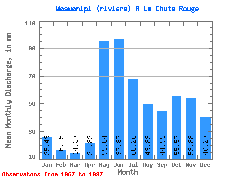
| Statistic | Jan | Feb | Mar | Apr | May | Jun | Jul | Aug | Sep | Oct | Nov | Dec | Annual |
|---|---|---|---|---|---|---|---|---|---|---|---|---|---|
| Mean | 25.49 | 16.29 | 14.37 | 21.82 | 95.83 | 97.37 | 68.25 | 49.82 | 44.95 | 55.57 | 53.88 | 40.27 | 577.94 |
| Standard Deviation | 4.97 | 2.28 | 2.19 | 8.27 | 18.42 | 24.85 | 14.78 | 11.33 | 14.54 | 15.24 | 14.58 | 10.60 | 66.40 |
| Min | 16.29 | 12.70 | 9.91 | 12.19 | 58.34 | 58.83 | 44.33 | 26.28 | 20.07 | 28.38 | 32.83 | 23.09 | 446.85 |
| Max | 37.27 | 20.58 | 20.99 | 45.10 | 142.72 | 197.45 | 105.78 | 71.61 | 76.05 | 87.31 | 96.69 | 66.07 | 747.20 |
| Coefficient of Variation | 0.20 | 0.14 | 0.15 | 0.38 | 0.19 | 0.26 | 0.22 | 0.23 | 0.32 | 0.27 | 0.27 | 0.26 | 0.12 |
 Return to R-Arctic Net Home Page