|
|
|||||||||||||||||
| Point ID: 5080 | Downloads | Plots | Site Data | Code: 03AB002 |
|
|
|||||||||||||||||
| Download | |
|---|---|
| Site Descriptor Information | Site Time Series Data |
| Link to all available data | |
| View: | Time Series | All |
| Units: | mm |
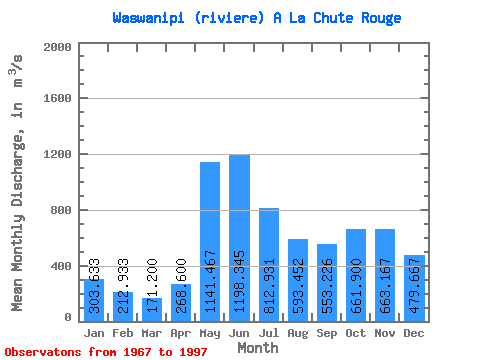
| Statistic | Jan | Feb | Mar | Apr | May | Jun | Jul | Aug | Sep | Oct | Nov | Dec | Annual |
|---|---|---|---|---|---|---|---|---|---|---|---|---|---|
| Mean | 303.63 | 212.93 | 171.20 | 268.60 | 1141.47 | 1198.35 | 812.93 | 593.45 | 553.23 | 661.90 | 663.17 | 479.67 | 584.17 |
| Standard Deviation | 59.22 | 29.81 | 26.09 | 101.72 | 219.42 | 305.87 | 176.06 | 134.96 | 179.00 | 181.53 | 179.41 | 126.30 | 67.12 |
| Min | 194.00 | 166.00 | 118.00 | 150.00 | 695.00 | 724.00 | 528.00 | 313.00 | 247.00 | 338.00 | 404.00 | 275.00 | 451.67 |
| Max | 444.00 | 269.00 | 250.00 | 555.00 | 1700.00 | 2430.00 | 1260.00 | 853.00 | 936.00 | 1040.00 | 1190.00 | 787.00 | 755.25 |
| Coefficient of Variation | 0.20 | 0.14 | 0.15 | 0.38 | 0.19 | 0.26 | 0.22 | 0.23 | 0.32 | 0.27 | 0.27 | 0.26 | 0.12 |
 Return to R-Arctic Net Home Page