|
|
|||||||||||||||||
| Point ID: 5077 | Downloads | Plots | Site Data | Code: 03AA002 |
|
|
|||||||||||||||||
| Download | |
|---|---|
| Site Descriptor Information | Site Time Series Data |
| Link to all available data | |
| View: | Time Series | All |
| Units: | m3/s |
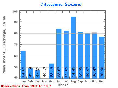
| Statistic | Jan | Feb | Mar | Apr | May | Jun | Jul | Aug | Sep | Oct | Nov | Dec | Annual |
|---|---|---|---|---|---|---|---|---|---|---|---|---|---|
| Mean | 64.62 | 49.56 | 47.38 | 40.17 | 53.18 | 83.67 | 82.02 | 94.42 | 80.75 | 80.05 | 80.47 | 76.96 | 812.15 |
| Standard Deviation | 11.95 | 6.62 | 4.28 | 3.15 | 4.58 | 15.70 | 13.74 | 29.49 | 25.73 | 20.38 | 12.58 | 14.94 | 98.52 |
| Min | 53.33 | 42.54 | 42.80 | 36.55 | 48.52 | 67.13 | 67.06 | 54.02 | 43.87 | 50.36 | 70.89 | 61.57 | 707.85 |
| Max | 77.14 | 55.68 | 51.27 | 42.31 | 57.68 | 98.36 | 94.07 | 124.74 | 103.46 | 94.76 | 98.81 | 97.28 | 903.64 |
| Coefficient of Variation | 0.18 | 0.13 | 0.09 | 0.08 | 0.09 | 0.19 | 0.17 | 0.31 | 0.32 | 0.26 | 0.16 | 0.19 | 0.12 |
 Return to R-Arctic Net Home Page