|
|
|||||||||||||||||
| Point ID: 458 | Downloads | Plots | Site Data | Code: 05DC001 |
|
|
|||||||||||||||||
| Download | |
|---|---|
| Site Descriptor Information | Site Time Series Data |
| Link to all available data | |
| View: | Time Series | All |
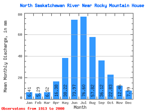
| Units: | m3/s |
| Statistic | Jan | Feb | Mar | Apr | May | Jun | Jul | Aug | Sep | Oct | Nov | Dec | Annual |
|---|---|---|---|---|---|---|---|---|---|---|---|---|---|
| Mean | 6.41 | 5.34 | 6.52 | 16.38 | 38.21 | 73.97 | 76.59 | 57.82 | 36.12 | 22.82 | 12.46 | 7.99 | 403.95 |
| Standard Deviation | 1.38 | 0.99 | 3.23 | 8.36 | 12.86 | 30.79 | 29.84 | 23.42 | 13.66 | 6.10 | 4.96 | 2.52 | 71.58 |
| Min | 4.14 | 3.79 | 4.24 | 5.33 | 19.67 | 28.04 | 28.73 | 18.82 | 15.62 | 11.81 | 5.94 | 3.97 | 307.81 |
| Max | 10.44 | 7.61 | 26.29 | 38.41 | 100.79 | 155.99 | 155.57 | 115.64 | 103.68 | 37.25 | 26.86 | 14.17 | 581.61 |
| Coefficient of Variation | 0.22 | 0.18 | 0.50 | 0.51 | 0.34 | 0.42 | 0.39 | 0.41 | 0.38 | 0.27 | 0.40 | 0.32 | 0.18 |
 Return to R-Arctic Net Home Page