|
|
|||||||||||||||||
| Point ID: 458 | Downloads | Plots | Site Data | Code: 05DC001 |
|
|
|||||||||||||||||
| Download | |
|---|---|
| Site Descriptor Information | Site Time Series Data |
| Link to all available data | |
| View: | Time Series | All |
| Units: | mm |
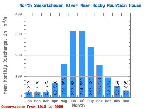
| Statistic | Jan | Feb | Mar | Apr | May | Jun | Jul | Aug | Sep | Oct | Nov | Dec | Annual |
|---|---|---|---|---|---|---|---|---|---|---|---|---|---|
| Mean | 26.32 | 24.07 | 26.77 | 69.51 | 156.96 | 313.93 | 314.59 | 237.48 | 153.27 | 93.75 | 52.86 | 32.80 | 140.79 |
| Standard Deviation | 5.68 | 4.45 | 13.27 | 35.49 | 52.82 | 130.69 | 122.56 | 96.20 | 57.98 | 25.07 | 21.07 | 10.36 | 24.95 |
| Min | 17.00 | 17.10 | 17.40 | 22.60 | 80.80 | 119.00 | 118.00 | 77.30 | 66.30 | 48.50 | 25.20 | 16.30 | 107.28 |
| Max | 42.90 | 34.30 | 108.00 | 163.00 | 414.00 | 662.00 | 639.00 | 475.00 | 440.00 | 153.00 | 114.00 | 58.20 | 202.72 |
| Coefficient of Variation | 0.22 | 0.18 | 0.50 | 0.51 | 0.34 | 0.42 | 0.39 | 0.41 | 0.38 | 0.27 | 0.40 | 0.32 | 0.18 |
 Return to R-Arctic Net Home Page