|
|
|||||||||||||||||
| Point ID: 4456 | Downloads | Plots | Site Data | Code: 05QE007 |
|
|
|||||||||||||||||
| Download | |
|---|---|
| Site Descriptor Information | Site Time Series Data |
| Link to all available data | |
| View: | Time Series | All |
| Units: | m3/s |
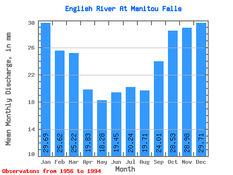
| Statistic | Jan | Feb | Mar | Apr | May | Jun | Jul | Aug | Sep | Oct | Nov | Dec | Annual |
|---|---|---|---|---|---|---|---|---|---|---|---|---|---|
| Mean | 29.69 | 25.84 | 25.21 | 19.83 | 18.27 | 19.45 | 20.23 | 19.71 | 24.01 | 28.52 | 28.98 | 29.71 | 290.93 |
| Standard Deviation | 5.88 | 6.11 | 7.83 | 8.97 | 8.26 | 11.61 | 11.64 | 9.10 | 10.45 | 10.03 | 7.75 | 7.30 | 77.21 |
| Min | 16.79 | 10.81 | 10.21 | 1.86 | 1.86 | 3.30 | 2.82 | 3.91 | 11.07 | 14.91 | 16.46 | 10.21 | 151.75 |
| Max | 38.43 | 35.61 | 37.78 | 37.48 | 42.12 | 56.88 | 53.99 | 38.14 | 63.12 | 62.61 | 48.69 | 43.35 | 480.44 |
| Coefficient of Variation | 0.20 | 0.24 | 0.31 | 0.45 | 0.45 | 0.60 | 0.57 | 0.46 | 0.43 | 0.35 | 0.27 | 0.25 | 0.27 |
 Return to R-Arctic Net Home Page