|
|
|||||||||||||||||
| Point ID: 4456 | Downloads | Plots | Site Data | Code: 05QE007 |
|
|
|||||||||||||||||
| Download | |
|---|---|
| Site Descriptor Information | Site Time Series Data |
| Link to all available data | |
| View: | Time Series | All |
| Units: | mm |
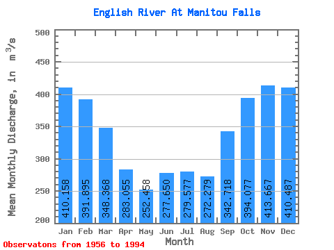
| Statistic | Jan | Feb | Mar | Apr | May | Jun | Jul | Aug | Sep | Oct | Nov | Dec | Annual |
|---|---|---|---|---|---|---|---|---|---|---|---|---|---|
| Mean | 410.16 | 391.89 | 348.37 | 283.06 | 252.46 | 277.65 | 279.58 | 272.28 | 342.72 | 394.08 | 413.67 | 410.49 | 341.08 |
| Standard Deviation | 81.23 | 92.66 | 108.16 | 127.99 | 114.16 | 165.75 | 160.82 | 125.79 | 149.20 | 138.57 | 110.56 | 100.89 | 90.52 |
| Min | 232.00 | 164.00 | 141.00 | 26.50 | 25.70 | 47.10 | 39.00 | 54.00 | 158.00 | 206.00 | 235.00 | 141.00 | 177.91 |
| Max | 531.00 | 540.00 | 522.00 | 535.00 | 582.00 | 812.00 | 746.00 | 527.00 | 901.00 | 865.00 | 695.00 | 599.00 | 563.25 |
| Coefficient of Variation | 0.20 | 0.24 | 0.31 | 0.45 | 0.45 | 0.60 | 0.57 | 0.46 | 0.43 | 0.35 | 0.27 | 0.25 | 0.27 |
 Return to R-Arctic Net Home Page