|
|
|||||||||||||||||
| Point ID: 4455 | Downloads | Plots | Site Data | Code: 05QE006 |
|
|
|||||||||||||||||
| Download | |
|---|---|
| Site Descriptor Information | Site Time Series Data |
| Link to all available data | |
| View: | Time Series | All |
| Units: | m3/s |
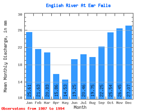
| Statistic | Jan | Feb | Mar | Apr | May | Jun | Jul | Aug | Sep | Oct | Nov | Dec | Annual |
|---|---|---|---|---|---|---|---|---|---|---|---|---|---|
| Mean | 25.61 | 21.81 | 20.82 | 15.86 | 14.53 | 19.25 | 20.46 | 19.74 | 22.25 | 25.53 | 26.45 | 27.06 | 259.79 |
| Standard Deviation | 10.33 | 9.75 | 10.40 | 8.51 | 7.63 | 13.34 | 12.98 | 10.54 | 10.85 | 10.74 | 10.39 | 10.18 | 82.29 |
| Min | 5.86 | 6.00 | 5.09 | 0.18 | 0.00 | 0.00 | 0.00 | 0.10 | 6.60 | 9.42 | 9.75 | 8.79 | 93.31 |
| Max | 45.24 | 44.64 | 45.14 | 41.34 | 37.63 | 77.56 | 60.56 | 53.56 | 73.24 | 65.43 | 64.02 | 46.26 | 496.91 |
| Coefficient of Variation | 0.40 | 0.45 | 0.50 | 0.54 | 0.53 | 0.69 | 0.63 | 0.53 | 0.49 | 0.42 | 0.39 | 0.38 | 0.32 |
 Return to R-Arctic Net Home Page