|
|
|||||||||||||||||
| Point ID: 4455 | Downloads | Plots | Site Data | Code: 05QE006 |
|
|
|||||||||||||||||
| Download | |
|---|---|
| Site Descriptor Information | Site Time Series Data |
| Link to all available data | |
| View: | Time Series | All |
| Units: | mm |
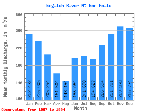
| Statistic | Jan | Feb | Mar | Apr | May | Jun | Jul | Aug | Sep | Oct | Nov | Dec | Annual |
|---|---|---|---|---|---|---|---|---|---|---|---|---|---|
| Mean | 252.47 | 236.00 | 205.29 | 161.50 | 143.19 | 196.06 | 201.69 | 194.63 | 226.59 | 251.70 | 269.38 | 266.77 | 217.31 |
| Standard Deviation | 101.83 | 105.45 | 102.57 | 86.68 | 75.25 | 135.85 | 127.93 | 103.88 | 110.49 | 105.92 | 105.86 | 100.30 | 68.83 |
| Min | 57.80 | 64.90 | 50.20 | 1.82 | 0.00 | 0.00 | 0.00 | 1.04 | 67.20 | 92.90 | 99.30 | 86.70 | 78.06 |
| Max | 446.00 | 483.00 | 445.00 | 421.00 | 371.00 | 790.00 | 597.00 | 528.00 | 746.00 | 645.00 | 652.00 | 456.00 | 415.67 |
| Coefficient of Variation | 0.40 | 0.45 | 0.50 | 0.54 | 0.53 | 0.69 | 0.63 | 0.53 | 0.49 | 0.42 | 0.39 | 0.38 | 0.32 |
 Return to R-Arctic Net Home Page