|
|
|||||||||||||||||
| Point ID: 4445 | Downloads | Plots | Site Data | Code: 05QD016 |
|
|
|||||||||||||||||
| Download | |
|---|---|
| Site Descriptor Information | Site Time Series Data |
| Link to all available data | |
| View: | Time Series | All |
| Units: | m3/s |
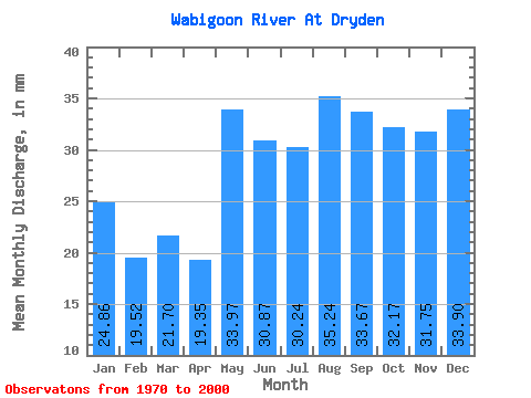
| Statistic | Jan | Feb | Mar | Apr | May | Jun | Jul | Aug | Sep | Oct | Nov | Dec | Annual |
|---|---|---|---|---|---|---|---|---|---|---|---|---|---|
| Mean | 24.86 | 19.69 | 21.70 | 19.35 | 33.97 | 30.87 | 30.23 | 35.24 | 33.67 | 32.16 | 31.75 | 33.90 | 350.03 |
| Standard Deviation | 64.06 | 44.68 | 42.16 | 29.17 | 37.70 | 30.81 | 49.74 | 110.71 | 104.14 | 99.09 | 105.39 | 125.87 | 819.99 |
| Min | 1.65 | 1.51 | 1.65 | 1.60 | 2.53 | 1.92 | 1.67 | 2.31 | 2.29 | 2.31 | 2.91 | 1.65 | 62.83 |
| Max | 348.14 | 237.63 | 217.73 | 162.28 | 163.01 | 152.14 | 281.77 | 628.75 | 586.02 | 560.05 | 595.03 | 711.42 | 4632.23 |
| Coefficient of Variation | 2.58 | 2.27 | 1.94 | 1.51 | 1.11 | 1.00 | 1.65 | 3.14 | 3.09 | 3.08 | 3.32 | 3.71 | 2.34 |
 Return to R-Arctic Net Home Page