|
|
|||||||||||||||||
| Point ID: 4445 | Downloads | Plots | Site Data | Code: 05QD016 |
|
|
|||||||||||||||||
| Download | |
|---|---|
| Site Descriptor Information | Site Time Series Data |
| Link to all available data | |
| View: | Time Series | All |
| Units: | mm |
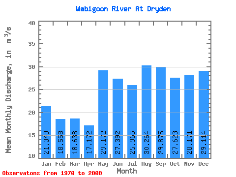
| Statistic | Jan | Feb | Mar | Apr | May | Jun | Jul | Aug | Sep | Oct | Nov | Dec | Annual |
|---|---|---|---|---|---|---|---|---|---|---|---|---|---|
| Mean | 21.35 | 18.56 | 18.64 | 17.17 | 29.17 | 27.39 | 25.96 | 30.26 | 29.88 | 27.62 | 28.17 | 29.11 | 25.51 |
| Standard Deviation | 55.02 | 42.12 | 36.21 | 25.89 | 32.38 | 27.34 | 42.72 | 95.09 | 92.41 | 85.10 | 93.52 | 108.11 | 59.76 |
| Min | 1.42 | 1.42 | 1.42 | 1.42 | 2.17 | 1.70 | 1.43 | 1.98 | 2.03 | 1.98 | 2.58 | 1.42 | 4.58 |
| Max | 299.00 | 224.00 | 187.00 | 144.00 | 140.00 | 135.00 | 242.00 | 540.00 | 520.00 | 481.00 | 528.00 | 611.00 | 337.58 |
| Coefficient of Variation | 2.58 | 2.27 | 1.94 | 1.51 | 1.11 | 1.00 | 1.65 | 3.14 | 3.09 | 3.08 | 3.32 | 3.71 | 2.34 |
 Return to R-Arctic Net Home Page