|
|
|||||||||||||||||
| Point ID: 4437 | Downloads | Plots | Site Data | Code: 05QD003 |
|
|
|||||||||||||||||
| Download | |
|---|---|
| Site Descriptor Information | Site Time Series Data |
| Link to all available data | |
| View: | Time Series | All |
| Units: | m3/s |
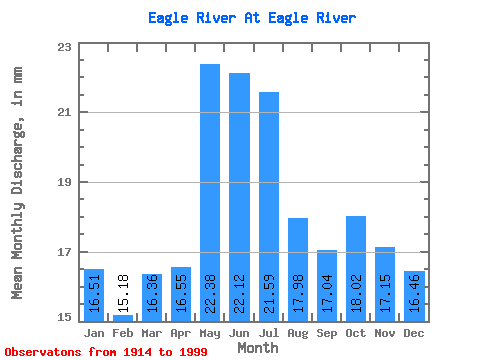
| Statistic | Jan | Feb | Mar | Apr | May | Jun | Jul | Aug | Sep | Oct | Nov | Dec | Annual |
|---|---|---|---|---|---|---|---|---|---|---|---|---|---|
| Mean | 16.50 | 15.31 | 16.36 | 16.55 | 22.38 | 22.12 | 21.59 | 17.98 | 17.04 | 18.02 | 17.15 | 16.46 | 220.44 |
| Standard Deviation | 15.23 | 14.69 | 16.79 | 19.99 | 19.82 | 19.34 | 16.82 | 14.57 | 16.99 | 14.86 | 14.84 | 12.25 | 179.59 |
| Min | 4.07 | 3.58 | 4.01 | 2.38 | 2.11 | 2.04 | 1.81 | 1.81 | 1.76 | 2.75 | 3.94 | 4.08 | 58.87 |
| Max | 97.62 | 94.30 | 109.89 | 128.05 | 97.52 | 94.39 | 87.81 | 87.81 | 81.48 | 80.66 | 75.59 | 76.39 | 1109.53 |
| Coefficient of Variation | 0.92 | 0.96 | 1.03 | 1.21 | 0.89 | 0.87 | 0.78 | 0.81 | 1.00 | 0.82 | 0.86 | 0.74 | 0.81 |
 Return to R-Arctic Net Home Page