|
|
|||||||||||||||||
| Point ID: 4437 | Downloads | Plots | Site Data | Code: 05QD003 |
|
|
|||||||||||||||||
| Download | |
|---|---|
| Site Descriptor Information | Site Time Series Data |
| Link to all available data | |
| View: | Time Series | All |
| Units: | mm |
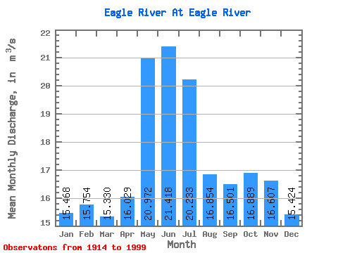
| Statistic | Jan | Feb | Mar | Apr | May | Jun | Jul | Aug | Sep | Oct | Nov | Dec | Annual |
|---|---|---|---|---|---|---|---|---|---|---|---|---|---|
| Mean | 15.47 | 15.75 | 15.33 | 16.03 | 20.97 | 21.42 | 20.23 | 16.85 | 16.50 | 16.89 | 16.61 | 15.42 | 17.53 |
| Standard Deviation | 14.27 | 15.11 | 15.73 | 19.36 | 18.58 | 18.73 | 15.77 | 13.66 | 16.45 | 13.93 | 14.37 | 11.48 | 14.28 |
| Min | 3.81 | 3.68 | 3.76 | 2.30 | 1.98 | 1.98 | 1.70 | 1.70 | 1.70 | 2.58 | 3.82 | 3.82 | 4.68 |
| Max | 91.50 | 97.00 | 103.00 | 124.00 | 91.40 | 91.40 | 82.30 | 82.30 | 78.90 | 75.60 | 73.20 | 71.60 | 88.24 |
| Coefficient of Variation | 0.92 | 0.96 | 1.03 | 1.21 | 0.89 | 0.87 | 0.78 | 0.81 | 1.00 | 0.82 | 0.86 | 0.74 | 0.81 |
 Return to R-Arctic Net Home Page