|
|
|||||||||||||||||
| Point ID: 4433 | Downloads | Plots | Site Data | Code: 05QC001 |
|
|
|||||||||||||||||
| Download | |
|---|---|
| Site Descriptor Information | Site Time Series Data |
| Link to all available data | |
| View: | Time Series | All |
| Units: | m3/s |
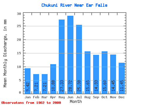
| Statistic | Jan | Feb | Mar | Apr | May | Jun | Jul | Aug | Sep | Oct | Nov | Dec | Annual |
|---|---|---|---|---|---|---|---|---|---|---|---|---|---|
| Mean | 9.42 | 7.27 | 7.21 | 10.88 | 27.32 | 28.72 | 25.38 | 15.65 | 14.33 | 15.60 | 14.45 | 11.45 | 188.79 |
| Standard Deviation | 4.93 | 3.02 | 2.64 | 5.96 | 17.03 | 17.43 | 12.86 | 9.06 | 11.60 | 10.62 | 8.83 | 6.73 | 64.67 |
| Min | 1.79 | 1.68 | 1.62 | 2.30 | 2.26 | 3.48 | 5.71 | 2.11 | 0.34 | 0.26 | 2.91 | 3.35 | 60.13 |
| Max | 23.41 | 14.78 | 14.21 | 32.77 | 77.29 | 85.35 | 52.91 | 45.07 | 40.99 | 37.12 | 44.99 | 32.93 | 341.90 |
| Coefficient of Variation | 0.52 | 0.42 | 0.37 | 0.55 | 0.62 | 0.61 | 0.51 | 0.58 | 0.81 | 0.68 | 0.61 | 0.59 | 0.34 |
 Return to R-Arctic Net Home Page