|
|
|||||||||||||||||
| Point ID: 4433 | Downloads | Plots | Site Data | Code: 05QC001 |
|
|
|||||||||||||||||
| Download | |
|---|---|
| Site Descriptor Information | Site Time Series Data |
| Link to all available data | |
| View: | Time Series | All |
| Units: | mm |
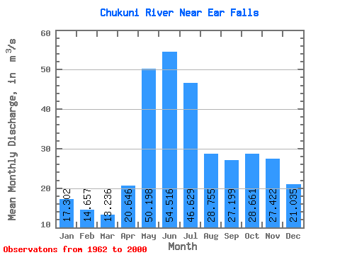
| Statistic | Jan | Feb | Mar | Apr | May | Jun | Jul | Aug | Sep | Oct | Nov | Dec | Annual |
|---|---|---|---|---|---|---|---|---|---|---|---|---|---|
| Mean | 17.30 | 14.66 | 13.24 | 20.65 | 50.20 | 54.52 | 46.63 | 28.75 | 27.20 | 28.66 | 27.42 | 21.04 | 29.43 |
| Standard Deviation | 9.05 | 6.09 | 4.85 | 11.31 | 31.30 | 33.09 | 23.62 | 16.65 | 22.01 | 19.50 | 16.76 | 12.37 | 10.08 |
| Min | 3.29 | 3.38 | 2.98 | 4.37 | 4.15 | 6.60 | 10.50 | 3.88 | 0.64 | 0.47 | 5.52 | 6.16 | 9.37 |
| Max | 43.00 | 29.80 | 26.10 | 62.20 | 142.00 | 162.00 | 97.20 | 82.80 | 77.80 | 68.20 | 85.40 | 60.50 | 53.30 |
| Coefficient of Variation | 0.52 | 0.42 | 0.37 | 0.55 | 0.62 | 0.61 | 0.51 | 0.58 | 0.81 | 0.68 | 0.61 | 0.59 | 0.34 |
 Return to R-Arctic Net Home Page