|
|
|||||||||||||||||
| Point ID: 4379 | Downloads | Plots | Site Data | Code: 04ME001 |
|
|
|||||||||||||||||
| Download | |
|---|---|
| Site Descriptor Information | Site Time Series Data |
| Link to all available data | |
| View: | Time Series | All |
| Units: | m3/s |
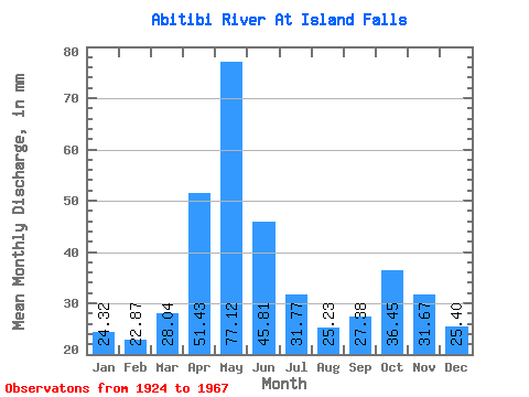
| Statistic | Jan | Feb | Mar | Apr | May | Jun | Jul | Aug | Sep | Oct | Nov | Dec | Annual |
|---|---|---|---|---|---|---|---|---|---|---|---|---|---|
| Mean | 24.31 | 23.07 | 28.04 | 51.44 | 77.11 | 45.81 | 31.77 | 25.23 | 27.38 | 36.45 | 31.67 | 25.40 | 420.10 |
| Standard Deviation | 5.12 | 5.79 | 7.63 | 17.84 | 32.61 | 19.47 | 12.03 | 6.15 | 9.69 | 19.11 | 10.34 | 5.76 | 55.37 |
| Min | 13.71 | 12.61 | 17.21 | 24.29 | 30.66 | 19.03 | 18.63 | 16.30 | 13.15 | 17.21 | 14.40 | 12.39 | 305.44 |
| Max | 37.65 | 44.44 | 50.45 | 93.54 | 179.83 | 107.69 | 74.78 | 45.02 | 62.86 | 104.66 | 58.73 | 43.47 | 553.57 |
| Coefficient of Variation | 0.21 | 0.25 | 0.27 | 0.35 | 0.42 | 0.42 | 0.38 | 0.24 | 0.35 | 0.52 | 0.33 | 0.23 | 0.13 |
 Return to R-Arctic Net Home Page