|
|
|||||||||||||||||
| Point ID: 4379 | Downloads | Plots | Site Data | Code: 04ME001 |
|
|
|||||||||||||||||
| Download | |
|---|---|
| Site Descriptor Information | Site Time Series Data |
| Link to all available data | |
|
|
| View: | Statistics | Time Series |
| Units: | m3/s |
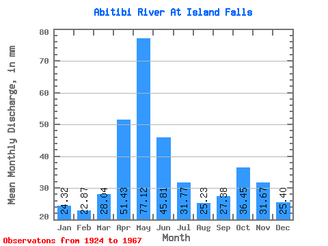
| Statistic | Jan | Feb | Mar | Apr | May | Jun | Jul | Aug | Sep | Oct | Nov | Dec | Annual |
|---|---|---|---|---|---|---|---|---|---|---|---|---|---|
| Mean | 24.31 | 23.07 | 28.04 | 51.44 | 77.11 | 45.81 | 31.77 | 25.23 | 27.38 | 36.45 | 31.67 | 25.40 | 420.10 |
| Standard Deviation | 5.12 | 5.79 | 7.63 | 17.84 | 32.61 | 19.47 | 12.03 | 6.15 | 9.69 | 19.11 | 10.34 | 5.76 | 55.37 |
| Min | 13.71 | 12.61 | 17.21 | 24.29 | 30.66 | 19.03 | 18.63 | 16.30 | 13.15 | 17.21 | 14.40 | 12.39 | 305.44 |
| Max | 37.65 | 44.44 | 50.45 | 93.54 | 179.83 | 107.69 | 74.78 | 45.02 | 62.86 | 104.66 | 58.73 | 43.47 | 553.57 |
| Coefficient of Variation | 0.21 | 0.25 | 0.27 | 0.35 | 0.42 | 0.42 | 0.38 | 0.24 | 0.35 | 0.52 | 0.33 | 0.23 | 0.13 |
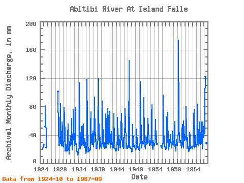
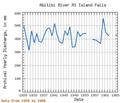
| Year | Jan | Feb | Mar | Apr | May | Jun | Jul | Aug | Sep | Oct | Nov | Dec | Annual | 1924 | 21.22 | 24.17 | 26.91 | 1925 | 53.43 | 81.64 | 59.25 | 43.08 | 22.91 | 1928 | 104.66 | 40.95 | 32.21 | 1929 | 26.52 | 24.28 | 29.50 | 45.45 | 86.68 | 58.35 | 32.47 | 25.49 | 31.43 | 60.42 | 48.46 | 26.39 | 494.87 | 1930 | 24.84 | 23.34 | 23.93 | 37.82 | 81.25 | 65.86 | 38.81 | 17.98 | 17.66 | 25.10 | 26.05 | 20.96 | 403.39 | 1931 | 18.37 | 16.50 | 18.76 | 38.69 | 57.57 | 23.92 | 20.96 | 16.30 | 13.15 | 23.03 | 38.82 | 30.14 | 315.85 | 1932 | 25.62 | 24.52 | 27.94 | 43.33 | 65.33 | 19.03 | 24.06 | 30.01 | 36.81 | 78.27 | 56.10 | 29.24 | 459.42 | 1933 | 27.30 | 24.28 | 28.07 | 69.75 | 81.38 | 35.94 | 21.61 | 21.86 | 17.03 | 17.21 | 14.40 | 12.39 | 371.35 | 1934 | 13.71 | 12.61 | 17.21 | 24.29 | 117.60 | 50.34 | 29.63 | 20.96 | 30.55 | 35.97 | 51.97 | 35.71 | 438.97 | 1935 | 25.36 | 25.11 | 28.59 | 50.21 | 57.18 | 37.44 | 27.94 | 23.16 | 23.42 | 35.71 | 24.54 | 20.05 | 378.75 | 1936 | 14.49 | 13.44 | 18.11 | 31.05 | 122.90 | 57.98 | 23.29 | 16.56 | 16.65 | 23.68 | 20.16 | 18.24 | 375.19 | 1937 | 18.11 | 16.97 | 20.18 | 54.34 | 75.04 | 30.05 | 42.56 | 29.37 | 27.17 | 41.40 | 45.20 | 30.66 | 430.07 | 1938 | 24.32 | 23.57 | 34.28 | 93.54 | 78.14 | 49.71 | 31.18 | 45.02 | 23.29 | 21.61 | 25.92 | 20.83 | 471.49 | 1939 | 23.68 | 27.82 | 33.90 | 42.20 | 123.81 | 39.07 | 57.57 | 21.09 | 26.30 | 37.52 | 26.67 | 24.32 | 482.29 | 1940 | 28.46 | 22.99 | 22.25 | 31.68 | 91.08 | 62.86 | 33.64 | 24.06 | 27.67 | 25.75 | 29.05 | 24.19 | 423.21 | 1941 | 21.99 | 20.27 | 24.45 | 70.12 | 58.99 | 25.80 | 22.90 | 33.90 | 62.86 | 79.95 | 58.73 | 34.28 | 514.06 | 1942 | 27.82 | 26.05 | 30.01 | 73.50 | 56.92 | 27.42 | 24.71 | 22.90 | 30.30 | 46.19 | 36.19 | 22.51 | 424.87 | 1943 | 22.90 | 22.63 | 22.77 | 39.07 | 59.38 | 69.75 | 31.31 | 24.58 | 22.54 | 18.37 | 21.41 | 18.24 | 373.41 | 1944 | 18.76 | 16.97 | 21.22 | 40.07 | 66.76 | 34.31 | 18.63 | 27.17 | 31.55 | 40.62 | 28.68 | 23.16 | 367.31 | 1945 | 24.19 | 20.51 | 43.47 | 56.72 | 63.91 | 70.75 | 43.21 | 24.19 | 25.92 | 28.20 | 35.94 | 22.12 | 459.04 | 1946 | 22.38 | 22.63 | 50.45 | 43.83 | 79.69 | 55.22 | 31.44 | 22.12 | 28.68 | 24.84 | 24.79 | 21.73 | 427.28 | 1947 | 22.25 | 21.57 | 24.58 | 29.68 | 150.07 | 107.69 | 23.68 | 23.93 | 21.04 | 22.38 | 20.79 | 22.12 | 488.90 | 1948 | 20.18 | 15.32 | 17.72 | 54.84 | 55.11 | 24.17 | 25.36 | 29.24 | 22.91 | 25.87 | 24.92 | 20.57 | 335.80 | 1949 | 19.79 | 18.74 | 20.96 | 48.71 | 45.93 | 47.83 | 25.87 | 23.42 | 22.29 | 22.64 | 23.04 | 20.83 | 340.38 | 1950 | 18.89 | 18.04 | 19.92 | 36.06 | 119.02 | 57.10 | 53.69 | 24.84 | 21.79 | 25.23 | 31.05 | 28.33 | 452.31 | 1951 | 28.46 | 25.81 | 32.73 | 92.54 | 36.35 | 31.05 | 26.52 | 21.09 | 21.16 | 39.33 | 34.18 | 28.33 | 418.39 | 1952 | 28.07 | 27.82 | 29.50 | 60.73 | 65.33 | 46.58 | 34.54 | 32.34 | 25.29 | 28.85 | 31.93 | 27.04 | 438.21 | 1953 | 32.99 | 27.82 | 40.88 | 70.87 | 85.77 | 27.30 | 22.51 | 20.31 | 32.56 | 26.00 | 26.17 | 26.00 | 439.10 | 1954 | 25.87 | 25.34 | 31.57 | 62.23 | 58.99 | 34.18 | 39.72 | 27.82 | 27.80 | 1955 | 25.87 | 25.67 | 22.51 | 1956 | 21.99 | 21.93 | 26.78 | 29.18 | 99.88 | 48.46 | 30.01 | 23.80 | 26.17 | 25.10 | 22.66 | 20.57 | 395.64 | 1957 | 20.70 | 19.45 | 25.36 | 65.61 | 30.66 | 34.06 | 74.78 | 19.79 | 19.16 | 21.61 | 34.18 | 24.58 | 389.80 | 1958 | 28.20 | 26.64 | 30.14 | 40.82 | 31.44 | 28.93 | 28.20 | 22.51 | 29.05 | 47.35 | 36.94 | 27.56 | 377.98 | 1959 | 27.17 | 26.05 | 30.01 | 47.71 | 61.19 | 25.04 | 22.64 | 18.24 | 20.79 | 34.28 | 25.17 | 26.91 | 365.02 | 1960 | 26.26 | 26.52 | 30.66 | 49.71 | 179.83 | 53.47 | 34.93 | 34.41 | 29.55 | 30.53 | 32.31 | 27.43 | 553.57 | 1961 | 28.59 | 20.63 | 26.13 | 44.58 | 56.54 | 40.82 | 30.79 | 22.64 | 59.85 | 46.06 | 36.69 | 34.02 | 447.23 | 1962 | 35.45 | 33.24 | 34.41 | 43.83 | 82.67 | 43.58 | 22.12 | 26.00 | 36.19 | 25.75 | 23.42 | 19.92 | 426.90 | 1963 | 17.72 | 16.27 | 21.35 | 43.45 | 41.27 | 31.93 | 21.99 | 22.51 | 22.66 | 23.80 | 21.41 | 21.09 | 305.44 | 1964 | 23.55 | 22.51 | 24.71 | 70.25 | 67.79 | 76.38 | 29.89 | 22.51 | 25.67 | 40.75 | 30.05 | 25.87 | 460.44 | 1965 | 23.80 | 24.64 | 28.46 | 29.43 | 86.16 | 27.17 | 27.56 | 25.87 | 37.06 | 60.16 | 29.93 | 28.98 | 427.92 | 1966 | 27.43 | 29.23 | 29.89 | 58.60 | 50.20 | 34.94 | 21.22 | 23.93 | 24.29 | 60.16 | 46.33 | 43.47 | 449.77 | 1967 | 37.65 | 44.44 | 44.50 | 90.03 | 126.14 | 70.37 | 27.69 | 28.98 | 26.80 |
|---|
 Return to R-Arctic Net Home Page