|
|
|||||||||||||||||
| Point ID: 4377 | Downloads | Plots | Site Data | Code: 04MD002 |
|
|
|||||||||||||||||
| Download | |
|---|---|
| Site Descriptor Information | Site Time Series Data |
| Link to all available data | |
| View: | Time Series | All |
| Units: | m3/s |
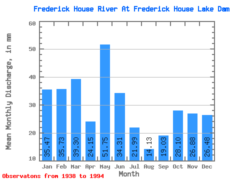
| Statistic | Jan | Feb | Mar | Apr | May | Jun | Jul | Aug | Sep | Oct | Nov | Dec | Annual |
|---|---|---|---|---|---|---|---|---|---|---|---|---|---|
| Mean | 35.46 | 36.03 | 39.29 | 24.15 | 51.74 | 34.31 | 21.99 | 14.13 | 19.03 | 28.10 | 26.88 | 26.47 | 354.07 |
| Standard Deviation | 11.69 | 11.45 | 13.50 | 21.45 | 38.88 | 22.06 | 16.21 | 13.47 | 16.05 | 20.03 | 20.94 | 10.52 | 66.54 |
| Min | 5.33 | 3.05 | 3.53 | 0.00 | 0.00 | 0.00 | 0.00 | 0.00 | 0.00 | 0.00 | 3.76 | 1.06 | 228.24 |
| Max | 69.98 | 61.13 | 68.68 | 104.76 | 195.02 | 104.76 | 82.67 | 73.34 | 80.92 | 75.21 | 148.11 | 66.06 | 544.88 |
| Coefficient of Variation | 0.33 | 0.32 | 0.34 | 0.89 | 0.75 | 0.64 | 0.74 | 0.95 | 0.84 | 0.71 | 0.78 | 0.40 | 0.19 |
 Return to R-Arctic Net Home Page