|
|
|||||||||||||||||
| Point ID: 4377 | Downloads | Plots | Site Data | Code: 04MD002 |
|
|
|||||||||||||||||
| Download | |
|---|---|
| Site Descriptor Information | Site Time Series Data |
| Link to all available data | |
| View: | Time Series | All |
| Units: | mm |
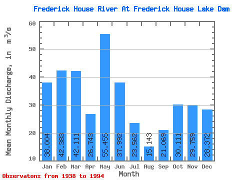
| Statistic | Jan | Feb | Mar | Apr | May | Jun | Jul | Aug | Sep | Oct | Nov | Dec | Annual |
|---|---|---|---|---|---|---|---|---|---|---|---|---|---|
| Mean | 38.00 | 42.38 | 42.11 | 26.74 | 55.45 | 37.99 | 23.56 | 15.14 | 21.07 | 30.11 | 29.76 | 28.37 | 32.20 |
| Standard Deviation | 12.53 | 13.46 | 14.47 | 23.75 | 41.66 | 24.42 | 17.38 | 14.43 | 17.77 | 21.47 | 23.19 | 11.28 | 6.05 |
| Min | 5.71 | 3.59 | 3.78 | 0.00 | 0.00 | 0.00 | 0.00 | 0.00 | 0.00 | 0.00 | 4.16 | 1.14 | 20.76 |
| Max | 75.00 | 71.90 | 73.60 | 116.00 | 209.00 | 116.00 | 88.60 | 78.60 | 89.60 | 80.60 | 164.00 | 70.80 | 49.55 |
| Coefficient of Variation | 0.33 | 0.32 | 0.34 | 0.89 | 0.75 | 0.64 | 0.74 | 0.95 | 0.84 | 0.71 | 0.78 | 0.40 | 0.19 |
 Return to R-Arctic Net Home Page