|
|
|||||||||||||||||
| Point ID: 4374 | Downloads | Plots | Site Data | Code: 04MC001 |
|
|
|||||||||||||||||
| Download | |
|---|---|
| Site Descriptor Information | Site Time Series Data |
| Link to all available data | |
| View: | Time Series | All |
| Units: | m3/s |
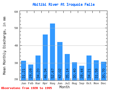
| Statistic | Jan | Feb | Mar | Apr | May | Jun | Jul | Aug | Sep | Oct | Nov | Dec | Annual |
|---|---|---|---|---|---|---|---|---|---|---|---|---|---|
| Mean | 31.20 | 29.34 | 34.20 | 46.34 | 52.66 | 42.02 | 35.13 | 30.39 | 28.44 | 34.20 | 31.58 | 30.69 | 426.19 |
| Standard Deviation | 7.53 | 7.41 | 8.11 | 11.25 | 27.66 | 19.53 | 13.46 | 5.27 | 6.14 | 15.03 | 10.05 | 7.30 | 73.26 |
| Min | 14.50 | 11.04 | 12.22 | 29.23 | 18.12 | 17.19 | 16.69 | 20.04 | 16.20 | 19.03 | 18.61 | 17.42 | 267.33 |
| Max | 52.35 | 61.27 | 52.76 | 81.46 | 158.06 | 117.71 | 94.44 | 46.31 | 53.79 | 101.28 | 70.55 | 52.15 | 704.17 |
| Coefficient of Variation | 0.24 | 0.25 | 0.24 | 0.24 | 0.53 | 0.47 | 0.38 | 0.17 | 0.22 | 0.44 | 0.32 | 0.24 | 0.17 |
 Return to R-Arctic Net Home Page