|
|
|||||||||||||||||
| Point ID: 4374 | Downloads | Plots | Site Data | Code: 04MC001 |
|
|
|||||||||||||||||
| Download | |
|---|---|
| Site Descriptor Information | Site Time Series Data |
| Link to all available data | |
| View: | Time Series | All |
| Units: | mm |
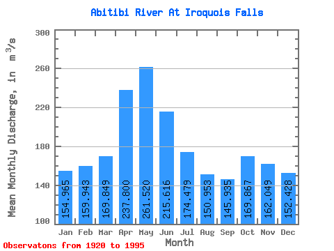
| Statistic | Jan | Feb | Mar | Apr | May | Jun | Jul | Aug | Sep | Oct | Nov | Dec | Annual |
|---|---|---|---|---|---|---|---|---|---|---|---|---|---|
| Mean | 154.97 | 159.94 | 169.85 | 237.80 | 261.52 | 215.62 | 174.48 | 150.95 | 145.94 | 169.87 | 162.05 | 152.43 | 179.60 |
| Standard Deviation | 37.40 | 40.39 | 40.25 | 57.71 | 137.39 | 100.23 | 66.86 | 26.16 | 31.48 | 74.65 | 51.56 | 36.27 | 30.87 |
| Min | 72.00 | 60.20 | 60.70 | 150.00 | 90.00 | 88.20 | 82.90 | 99.50 | 83.10 | 94.50 | 95.50 | 86.50 | 112.66 |
| Max | 260.00 | 334.00 | 262.00 | 418.00 | 785.00 | 604.00 | 469.00 | 230.00 | 276.00 | 503.00 | 362.00 | 259.00 | 296.75 |
| Coefficient of Variation | 0.24 | 0.25 | 0.24 | 0.24 | 0.53 | 0.47 | 0.38 | 0.17 | 0.22 | 0.44 | 0.32 | 0.24 | 0.17 |
 Return to R-Arctic Net Home Page