|
|
|||||||||||||||||
| Point ID: 4363 | Downloads | Plots | Site Data | Code: 04LC001 |
|
|
|||||||||||||||||
| Download | |
|---|---|
| Site Descriptor Information | Site Time Series Data |
| Link to all available data | |
| View: | Time Series | All |
| Units: | m3/s |
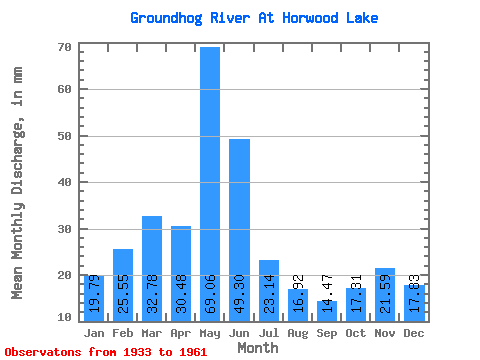
| Statistic | Jan | Feb | Mar | Apr | May | Jun | Jul | Aug | Sep | Oct | Nov | Dec | Annual |
|---|---|---|---|---|---|---|---|---|---|---|---|---|---|
| Mean | 19.79 | 25.77 | 32.77 | 30.48 | 69.05 | 49.30 | 23.13 | 16.91 | 14.47 | 17.31 | 21.59 | 17.83 | 328.85 |
| Standard Deviation | 6.21 | 6.38 | 6.38 | 18.79 | 38.08 | 26.94 | 14.24 | 9.84 | 11.03 | 18.00 | 15.52 | 11.86 | 93.50 |
| Min | 6.57 | 11.15 | 18.83 | 6.93 | 15.42 | 1.25 | 0.00 | 0.00 | 0.00 | 0.00 | 0.00 | 3.34 | 180.54 |
| Max | 30.28 | 39.03 | 49.59 | 90.76 | 183.57 | 119.99 | 46.57 | 39.18 | 45.07 | 80.26 | 66.76 | 54.67 | 532.69 |
| Coefficient of Variation | 0.31 | 0.25 | 0.20 | 0.62 | 0.55 | 0.55 | 0.62 | 0.58 | 0.76 | 1.04 | 0.72 | 0.67 | 0.28 |
 Return to R-Arctic Net Home Page