|
|
|||||||||||||||||
| Point ID: 4363 | Downloads | Plots | Site Data | Code: 04LC001 |
|
|
|||||||||||||||||
| Download | |
|---|---|
| Site Descriptor Information | Site Time Series Data |
| Link to all available data | |
| View: | Time Series | All |
| Units: | mm |
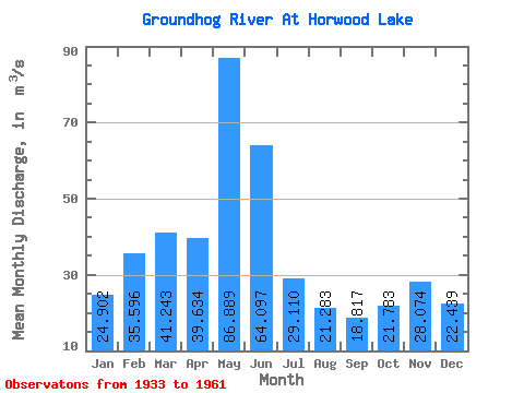
| Statistic | Jan | Feb | Mar | Apr | May | Jun | Jul | Aug | Sep | Oct | Nov | Dec | Annual |
|---|---|---|---|---|---|---|---|---|---|---|---|---|---|
| Mean | 24.90 | 35.60 | 41.24 | 39.63 | 86.89 | 64.10 | 29.11 | 21.28 | 18.82 | 21.78 | 28.07 | 22.44 | 35.12 |
| Standard Deviation | 7.81 | 8.82 | 8.03 | 24.43 | 47.92 | 35.03 | 17.92 | 12.38 | 14.34 | 22.65 | 20.18 | 14.92 | 9.98 |
| Min | 8.27 | 15.40 | 23.70 | 9.01 | 19.40 | 1.63 | 0.00 | 0.00 | 0.00 | 0.00 | 0.00 | 4.20 | 19.28 |
| Max | 38.10 | 53.90 | 62.40 | 118.00 | 231.00 | 156.00 | 58.60 | 49.30 | 58.60 | 101.00 | 86.80 | 68.80 | 56.88 |
| Coefficient of Variation | 0.31 | 0.25 | 0.20 | 0.62 | 0.55 | 0.55 | 0.62 | 0.58 | 0.76 | 1.04 | 0.72 | 0.67 | 0.28 |
 Return to R-Arctic Net Home Page