|
|
|||||||||||||||||
| Point ID: 4347 | Downloads | Plots | Site Data | Code: 04HA001 |
|
|
|||||||||||||||||
| Download | |
|---|---|
| Site Descriptor Information | Site Time Series Data |
| Link to all available data | |
| View: | Time Series | All |
| Units: | m3/s |
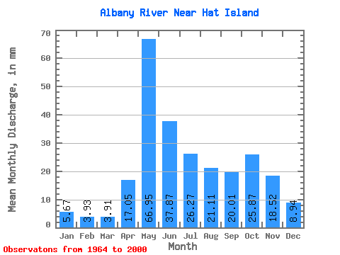
| Statistic | Jan | Feb | Mar | Apr | May | Jun | Jul | Aug | Sep | Oct | Nov | Dec | Annual |
|---|---|---|---|---|---|---|---|---|---|---|---|---|---|
| Mean | 5.67 | 3.96 | 3.91 | 17.05 | 66.94 | 37.87 | 26.27 | 21.10 | 20.00 | 25.87 | 18.52 | 8.94 | 256.37 |
| Standard Deviation | 2.21 | 1.53 | 1.45 | 10.90 | 17.75 | 15.21 | 12.17 | 13.55 | 14.01 | 13.12 | 8.61 | 3.99 | 73.70 |
| Min | 1.85 | 1.60 | 1.73 | 3.19 | 20.93 | 17.75 | 7.58 | 4.43 | 2.50 | 2.75 | 2.88 | 2.08 | 134.74 |
| Max | 10.76 | 8.11 | 6.79 | 39.10 | 123.01 | 91.60 | 49.25 | 63.32 | 65.68 | 59.69 | 45.03 | 21.15 | 421.69 |
| Coefficient of Variation | 0.39 | 0.39 | 0.37 | 0.64 | 0.27 | 0.40 | 0.46 | 0.64 | 0.70 | 0.51 | 0.47 | 0.45 | 0.29 |
 Return to R-Arctic Net Home Page