|
|
|||||||||||||||||
| Point ID: 4347 | Downloads | Plots | Site Data | Code: 04HA001 |
|
|
|||||||||||||||||
| Download | |
|---|---|
| Site Descriptor Information | Site Time Series Data |
| Link to all available data | |
| View: | Time Series | All |
| Units: | mm |
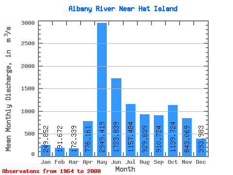
| Statistic | Jan | Feb | Mar | Apr | May | Jun | Jul | Aug | Sep | Oct | Nov | Dec | Annual |
|---|---|---|---|---|---|---|---|---|---|---|---|---|---|
| Mean | 249.85 | 191.67 | 172.34 | 776.16 | 2949.42 | 1723.84 | 1157.48 | 929.84 | 910.72 | 1139.72 | 843.07 | 393.98 | 958.56 |
| Standard Deviation | 97.29 | 73.90 | 63.95 | 496.23 | 782.34 | 692.21 | 536.15 | 597.05 | 637.89 | 578.11 | 391.84 | 175.91 | 275.55 |
| Min | 81.40 | 77.50 | 76.30 | 145.00 | 922.00 | 808.00 | 334.00 | 195.00 | 114.00 | 121.00 | 131.00 | 91.50 | 503.79 |
| Max | 474.00 | 392.00 | 299.00 | 1780.00 | 5420.00 | 4170.00 | 2170.00 | 2790.00 | 2990.00 | 2630.00 | 2050.00 | 932.00 | 1576.67 |
| Coefficient of Variation | 0.39 | 0.39 | 0.37 | 0.64 | 0.27 | 0.40 | 0.46 | 0.64 | 0.70 | 0.51 | 0.47 | 0.45 | 0.29 |
 Return to R-Arctic Net Home Page