|
|
|||||||||||||||||
| Point ID: 4341 | Downloads | Plots | Site Data | Code: 04GB004 |
|
|
|||||||||||||||||
| Download | |
|---|---|
| Site Descriptor Information | Site Time Series Data |
| Link to all available data | |
| View: | Time Series | All |
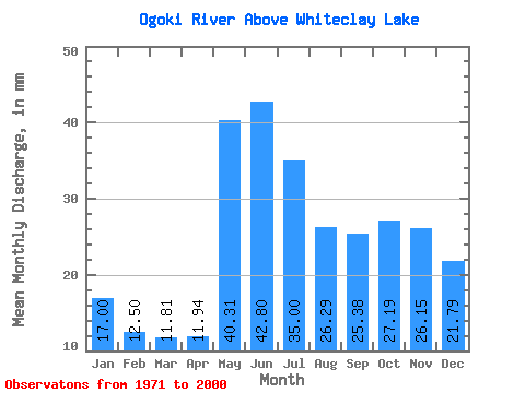
| Units: | m3/s |
| Statistic | Jan | Feb | Mar | Apr | May | Jun | Jul | Aug | Sep | Oct | Nov | Dec | Annual |
|---|---|---|---|---|---|---|---|---|---|---|---|---|---|
| Mean | 17.00 | 12.61 | 11.80 | 11.94 | 40.30 | 42.80 | 34.99 | 26.29 | 25.38 | 27.19 | 26.15 | 21.78 | 295.41 |
| Standard Deviation | 5.68 | 3.23 | 2.26 | 2.24 | 17.65 | 22.20 | 13.12 | 8.51 | 17.56 | 18.50 | 15.56 | 10.83 | 83.01 |
| Min | 7.34 | 6.54 | 7.08 | 7.11 | 13.51 | 15.34 | 12.67 | 10.07 | 7.84 | 6.43 | 5.21 | 4.81 | 149.77 |
| Max | 29.65 | 19.15 | 17.24 | 17.77 | 86.80 | 124.74 | 69.82 | 39.93 | 80.07 | 76.28 | 68.27 | 49.26 | 476.64 |
| Coefficient of Variation | 0.33 | 0.26 | 0.19 | 0.19 | 0.44 | 0.52 | 0.38 | 0.32 | 0.69 | 0.68 | 0.59 | 0.50 | 0.28 |
 Return to R-Arctic Net Home Page