|
|
|||||||||||||||||
| Point ID: 4341 | Downloads | Plots | Site Data | Code: 04GB004 |
|
|
|||||||||||||||||
| Download | |
|---|---|
| Site Descriptor Information | Site Time Series Data |
| Link to all available data | |
| View: | Time Series | All |
| Units: | mm |
| Statistic | Jan | Feb | Mar | Apr | May | Jun | Jul | Aug | Sep | Oct | Nov | Dec | Annual |
|---|---|---|---|---|---|---|---|---|---|---|---|---|---|
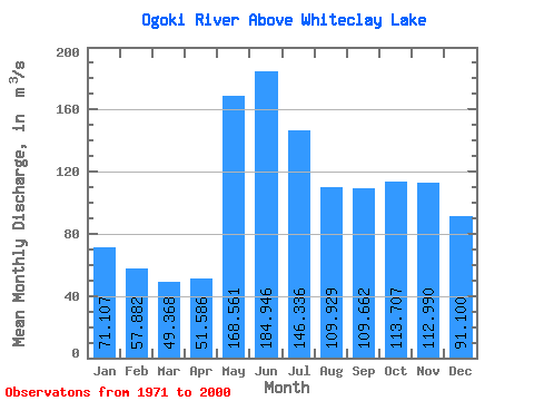
| Mean | 71.11 | 57.88 | 49.37 | 51.59 | 168.56 | 184.95 | 146.34 | 109.93 | 109.66 | 113.71 | 112.99 | 91.10 | 104.83 |
| Standard Deviation | 23.77 | 14.81 | 9.47 | 9.66 | 73.82 | 95.91 | 54.89 | 35.59 | 75.86 | 77.39 | 67.22 | 45.30 | 29.46 |
| Min | 30.70 | 30.00 | 29.60 | 30.70 | 56.50 | 66.30 | 53.00 | 42.10 | 33.90 | 26.90 | 22.50 | 20.10 | 53.15 |
| Max | 124.00 | 87.90 | 72.10 | 76.80 | 363.00 | 539.00 | 292.00 | 167.00 | 346.00 | 319.00 | 295.00 | 206.00 | 169.15 |
| Coefficient of Variation | 0.33 | 0.26 | 0.19 | 0.19 | 0.44 | 0.52 | 0.38 | 0.32 | 0.69 | 0.68 | 0.59 | 0.50 | 0.28 |
 Return to R-Arctic Net Home Page