|
|
|||||||||||||||||
| Point ID: 4340 | Downloads | Plots | Site Data | Code: 04GB001 |
|
|
|||||||||||||||||
| Download | |
|---|---|
| Site Descriptor Information | Site Time Series Data |
| Link to all available data | |
| View: | Time Series | All |
| Units: | m3/s |
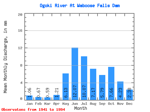
| Statistic | Jan | Feb | Mar | Apr | May | Jun | Jul | Aug | Sep | Oct | Nov | Dec | Annual |
|---|---|---|---|---|---|---|---|---|---|---|---|---|---|
| Mean | 1.06 | 0.67 | 0.59 | 1.21 | 6.13 | 12.07 | 10.07 | 7.17 | 5.79 | 7.66 | 4.23 | 2.38 | 51.16 |
| Standard Deviation | 4.21 | 2.55 | 2.22 | 4.07 | 12.38 | 28.94 | 19.25 | 16.01 | 13.60 | 19.46 | 12.24 | 7.70 | 80.47 |
| Min | 0.00 | 0.00 | 0.00 | 0.00 | 0.00 | 0.00 | 0.00 | 0.00 | 0.00 | 0.00 | 0.00 | 0.00 | 0.00 |
| Max | 26.58 | 14.55 | 12.37 | 24.59 | 49.03 | 140.84 | 70.30 | 63.01 | 62.89 | 104.17 | 59.46 | 40.37 | 268.01 |
| Coefficient of Variation | 3.96 | 3.78 | 3.77 | 3.35 | 2.02 | 2.40 | 1.91 | 2.23 | 2.35 | 2.54 | 2.89 | 3.24 | 1.57 |
 Return to R-Arctic Net Home Page