|
|
|||||||||||||||||
| Point ID: 4340 | Downloads | Plots | Site Data | Code: 04GB001 |
|
|
|||||||||||||||||
| Download | |
|---|---|
| Site Descriptor Information | Site Time Series Data |
| Link to all available data | |
| View: | Time Series | All |
| Units: | mm |
| Statistic | Jan | Feb | Mar | Apr | May | Jun | Jul | Aug | Sep | Oct | Nov | Dec | Annual |
|---|---|---|---|---|---|---|---|---|---|---|---|---|---|
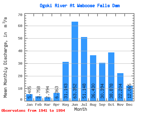
| Mean | 5.41 | 3.76 | 2.99 | 6.36 | 31.14 | 63.35 | 51.15 | 36.43 | 30.39 | 38.88 | 22.20 | 12.06 | 22.05 |
| Standard Deviation | 21.39 | 14.19 | 11.27 | 21.34 | 62.86 | 151.84 | 97.77 | 81.33 | 71.34 | 98.83 | 64.25 | 39.12 | 34.68 |
| Min | 0.00 | 0.00 | 0.00 | 0.00 | 0.00 | 0.00 | 0.00 | 0.00 | 0.00 | 0.00 | 0.00 | 0.00 | 0.00 |
| Max | 135.00 | 81.10 | 62.80 | 129.00 | 249.00 | 739.00 | 357.00 | 320.00 | 330.00 | 529.00 | 312.00 | 205.00 | 115.49 |
| Coefficient of Variation | 3.96 | 3.78 | 3.77 | 3.35 | 2.02 | 2.40 | 1.91 | 2.23 | 2.35 | 2.54 | 2.89 | 3.24 | 1.57 |
 Return to R-Arctic Net Home Page