|
|
|||||||||||||||||
| Point ID: 4335 | Downloads | Plots | Site Data | Code: 04FA003 |
|
|
|||||||||||||||||
| Download | |
|---|---|
| Site Descriptor Information | Site Time Series Data |
| Link to all available data | |
| View: | Time Series | All |
| Units: | m3/s |
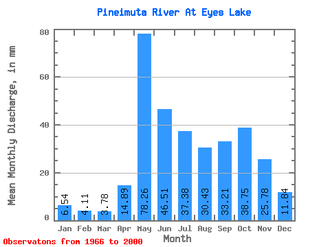
| Statistic | Jan | Feb | Mar | Apr | May | Jun | Jul | Aug | Sep | Oct | Nov | Dec | Annual |
|---|---|---|---|---|---|---|---|---|---|---|---|---|---|
| Mean | 6.54 | 4.15 | 3.78 | 14.89 | 78.25 | 46.51 | 37.38 | 30.43 | 33.21 | 38.74 | 25.78 | 11.84 | 332.37 |
| Standard Deviation | 2.30 | 1.26 | 1.09 | 12.43 | 32.58 | 26.64 | 21.63 | 21.24 | 23.58 | 21.66 | 13.35 | 4.46 | 117.41 |
| Min | 3.33 | 2.34 | 2.03 | 2.83 | 16.72 | 9.84 | 8.14 | 5.85 | 5.29 | 14.43 | 8.68 | 5.52 | 126.27 |
| Max | 12.35 | 7.52 | 6.34 | 40.47 | 166.69 | 120.61 | 95.64 | 87.99 | 99.45 | 89.63 | 59.77 | 20.88 | 530.86 |
| Coefficient of Variation | 0.35 | 0.30 | 0.29 | 0.83 | 0.42 | 0.57 | 0.58 | 0.70 | 0.71 | 0.56 | 0.52 | 0.38 | 0.35 |
 Return to R-Arctic Net Home Page