|
|
|||||||||||||||||
| Point ID: 4335 | Downloads | Plots | Site Data | Code: 04FA003 |
|
|
|||||||||||||||||
| Download | |
|---|---|
| Site Descriptor Information | Site Time Series Data |
| Link to all available data | |
| View: | Time Series | All |
| Units: | mm |
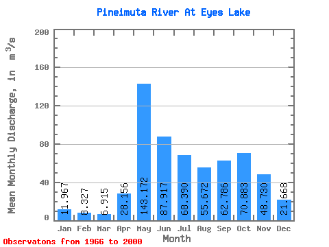
| Statistic | Jan | Feb | Mar | Apr | May | Jun | Jul | Aug | Sep | Oct | Nov | Dec | Annual |
|---|---|---|---|---|---|---|---|---|---|---|---|---|---|
| Mean | 11.97 | 8.33 | 6.92 | 28.16 | 143.17 | 87.92 | 68.39 | 55.67 | 62.79 | 70.88 | 48.73 | 21.67 | 51.60 |
| Standard Deviation | 4.20 | 2.53 | 1.99 | 23.49 | 59.62 | 50.37 | 39.57 | 38.86 | 44.58 | 39.63 | 25.24 | 8.16 | 18.23 |
| Min | 6.09 | 4.71 | 3.71 | 5.34 | 30.60 | 18.60 | 14.90 | 10.70 | 10.00 | 26.40 | 16.40 | 10.10 | 19.60 |
| Max | 22.60 | 15.10 | 11.60 | 76.50 | 305.00 | 228.00 | 175.00 | 161.00 | 188.00 | 164.00 | 113.00 | 38.20 | 82.42 |
| Coefficient of Variation | 0.35 | 0.30 | 0.29 | 0.83 | 0.42 | 0.57 | 0.58 | 0.70 | 0.71 | 0.56 | 0.52 | 0.38 | 0.35 |
 Return to R-Arctic Net Home Page