|
|
|||||||||||||||||
| Point ID: 4333 | Downloads | Plots | Site Data | Code: 04FA001 |
|
|
|||||||||||||||||
| Download | |
|---|---|
| Site Descriptor Information | Site Time Series Data |
| Link to all available data | |
| View: | Time Series | All |
| Units: | m3/s |
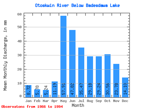
| Statistic | Jan | Feb | Mar | Apr | May | Jun | Jul | Aug | Sep | Oct | Nov | Dec | Annual |
|---|---|---|---|---|---|---|---|---|---|---|---|---|---|
| Mean | 8.72 | 5.83 | 5.24 | 11.20 | 57.91 | 47.82 | 35.47 | 29.18 | 29.24 | 30.55 | 23.78 | 14.10 | 298.81 |
| Standard Deviation | 3.15 | 1.73 | 1.27 | 6.64 | 28.91 | 29.57 | 17.37 | 16.80 | 20.66 | 20.34 | 15.05 | 6.15 | 121.08 |
| Min | 3.51 | 2.66 | 2.63 | 4.37 | 10.52 | 7.88 | 10.70 | 5.97 | 4.78 | 6.36 | 6.24 | 4.64 | 148.90 |
| Max | 15.57 | 9.23 | 7.55 | 26.81 | 130.48 | 148.73 | 79.66 | 58.55 | 72.78 | 91.25 | 65.88 | 27.34 | 549.94 |
| Coefficient of Variation | 0.36 | 0.30 | 0.24 | 0.59 | 0.50 | 0.62 | 0.49 | 0.58 | 0.71 | 0.67 | 0.63 | 0.44 | 0.41 |
 Return to R-Arctic Net Home Page