|
|
|||||||||||||||||
| Point ID: 4333 | Downloads | Plots | Site Data | Code: 04FA001 |
|
|
|||||||||||||||||
| Download | |
|---|---|
| Site Descriptor Information | Site Time Series Data |
| Link to all available data | |
| View: | Time Series | All |
| Units: | mm |
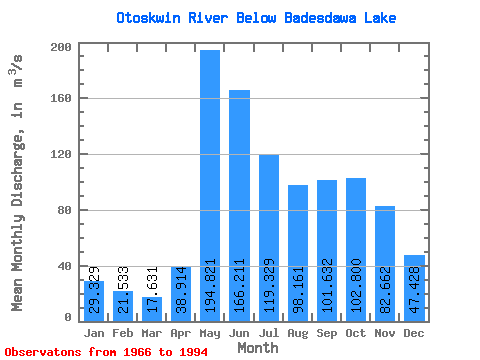
| Statistic | Jan | Feb | Mar | Apr | May | Jun | Jul | Aug | Sep | Oct | Nov | Dec | Annual |
|---|---|---|---|---|---|---|---|---|---|---|---|---|---|
| Mean | 29.33 | 21.53 | 17.63 | 38.91 | 194.82 | 166.21 | 119.33 | 98.16 | 101.63 | 102.80 | 82.66 | 47.43 | 85.31 |
| Standard Deviation | 10.59 | 6.41 | 4.27 | 23.09 | 97.28 | 102.79 | 58.43 | 56.53 | 71.81 | 68.44 | 52.31 | 20.68 | 34.57 |
| Min | 11.80 | 9.83 | 8.86 | 15.20 | 35.40 | 27.40 | 36.00 | 20.10 | 16.60 | 21.40 | 21.70 | 15.60 | 42.51 |
| Max | 52.40 | 34.10 | 25.40 | 93.20 | 439.00 | 517.00 | 268.00 | 197.00 | 253.00 | 307.00 | 229.00 | 92.00 | 157.00 |
| Coefficient of Variation | 0.36 | 0.30 | 0.24 | 0.59 | 0.50 | 0.62 | 0.49 | 0.58 | 0.71 | 0.67 | 0.63 | 0.44 | 0.41 |
 Return to R-Arctic Net Home Page