|
|
|||||||||||||||||
| Point ID: 4332 | Downloads | Plots | Site Data | Code: 04EA001 |
|
|
|||||||||||||||||
| Download | |
|---|---|
| Site Descriptor Information | Site Time Series Data |
| Link to all available data | |
| View: | Time Series | All |
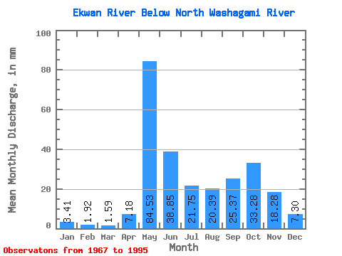
| Units: | m3/s |
| Statistic | Jan | Feb | Mar | Apr | May | Jun | Jul | Aug | Sep | Oct | Nov | Dec | Annual |
|---|---|---|---|---|---|---|---|---|---|---|---|---|---|
| Mean | 3.41 | 1.94 | 1.59 | 7.18 | 84.52 | 38.85 | 21.75 | 20.39 | 25.37 | 33.27 | 18.28 | 7.30 | 262.16 |
| Standard Deviation | 1.50 | 0.69 | 0.50 | 11.45 | 37.10 | 22.98 | 14.23 | 21.62 | 16.66 | 20.56 | 12.58 | 4.00 | 90.87 |
| Min | 1.12 | 0.79 | 0.60 | 0.96 | 34.51 | 10.67 | 2.70 | 2.51 | 2.32 | 2.30 | 1.81 | 1.43 | 118.60 |
| Max | 8.11 | 3.31 | 2.50 | 44.36 | 185.66 | 104.43 | 71.07 | 91.41 | 64.80 | 78.80 | 52.59 | 17.87 | 485.10 |
| Coefficient of Variation | 0.44 | 0.35 | 0.31 | 1.59 | 0.44 | 0.59 | 0.65 | 1.06 | 0.66 | 0.62 | 0.69 | 0.55 | 0.35 |
 Return to R-Arctic Net Home Page