|
|
|||||||||||||||||
| Point ID: 4332 | Downloads | Plots | Site Data | Code: 04EA001 |
|
|
|||||||||||||||||
| Download | |
|---|---|
| Site Descriptor Information | Site Time Series Data |
| Link to all available data | |
| View: | Time Series | All |
| Units: | mm |
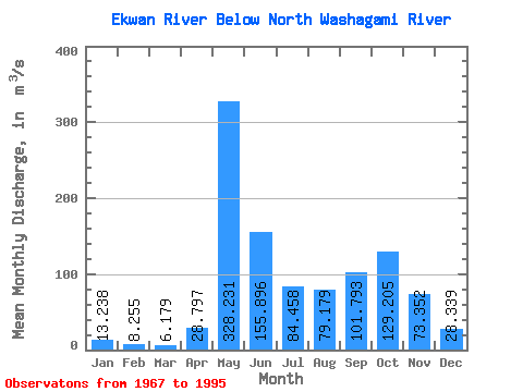
| Statistic | Jan | Feb | Mar | Apr | May | Jun | Jul | Aug | Sep | Oct | Nov | Dec | Annual |
|---|---|---|---|---|---|---|---|---|---|---|---|---|---|
| Mean | 13.24 | 8.26 | 6.18 | 28.80 | 328.23 | 155.90 | 84.46 | 79.18 | 101.79 | 129.21 | 73.35 | 28.34 | 86.39 |
| Standard Deviation | 5.84 | 2.93 | 1.94 | 45.93 | 144.07 | 92.21 | 55.26 | 83.98 | 66.86 | 79.83 | 50.48 | 15.54 | 29.95 |
| Min | 4.34 | 3.38 | 2.32 | 3.87 | 134.00 | 42.80 | 10.50 | 9.75 | 9.32 | 8.94 | 7.25 | 5.56 | 39.08 |
| Max | 31.50 | 14.10 | 9.73 | 178.00 | 721.00 | 419.00 | 276.00 | 355.00 | 260.00 | 306.00 | 211.00 | 69.40 | 159.85 |
| Coefficient of Variation | 0.44 | 0.35 | 0.31 | 1.59 | 0.44 | 0.59 | 0.65 | 1.06 | 0.66 | 0.62 | 0.69 | 0.55 | 0.35 |
 Return to R-Arctic Net Home Page