|
|
|||||||||||||||||
| Point ID: 4331 | Downloads | Plots | Site Data | Code: 04DC002 |
|
|
|||||||||||||||||
| Download | |
|---|---|
| Site Descriptor Information | Site Time Series Data |
| Link to all available data | |
| View: | Time Series | All |
| Units: | m3/s |
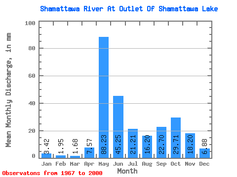
| Statistic | Jan | Feb | Mar | Apr | May | Jun | Jul | Aug | Sep | Oct | Nov | Dec | Annual |
|---|---|---|---|---|---|---|---|---|---|---|---|---|---|
| Mean | 3.42 | 1.96 | 1.68 | 7.57 | 88.22 | 45.25 | 21.21 | 16.20 | 22.70 | 29.71 | 18.20 | 6.88 | 259.61 |
| Standard Deviation | 1.34 | 0.71 | 0.66 | 13.30 | 35.14 | 26.91 | 14.34 | 18.76 | 19.52 | 18.37 | 11.85 | 3.55 | 81.71 |
| Min | 0.74 | 0.34 | 0.23 | 0.56 | 22.91 | 9.08 | 2.67 | 1.84 | 1.19 | 1.61 | 1.39 | 1.03 | 103.95 |
| Max | 6.37 | 2.95 | 2.97 | 57.78 | 176.26 | 122.72 | 63.11 | 80.74 | 79.25 | 76.76 | 49.36 | 17.57 | 459.22 |
| Coefficient of Variation | 0.39 | 0.36 | 0.39 | 1.76 | 0.40 | 0.59 | 0.68 | 1.16 | 0.86 | 0.62 | 0.65 | 0.52 | 0.32 |
 Return to R-Arctic Net Home Page