|
|
|||||||||||||||||
| Point ID: 4331 | Downloads | Plots | Site Data | Code: 04DC002 |
|
|
|||||||||||||||||
| Download | |
|---|---|
| Site Descriptor Information | Site Time Series Data |
| Link to all available data | |
| View: | Time Series | All |
| Units: | mm |
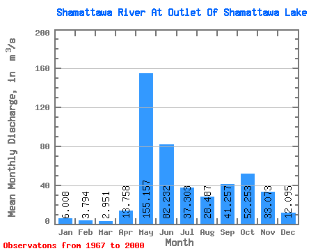
| Statistic | Jan | Feb | Mar | Apr | May | Jun | Jul | Aug | Sep | Oct | Nov | Dec | Annual |
|---|---|---|---|---|---|---|---|---|---|---|---|---|---|
| Mean | 6.01 | 3.79 | 2.95 | 13.76 | 155.16 | 82.23 | 37.30 | 28.49 | 41.26 | 52.25 | 33.07 | 12.10 | 38.74 |
| Standard Deviation | 2.35 | 1.38 | 1.16 | 24.17 | 61.81 | 48.91 | 25.22 | 33.00 | 35.47 | 32.30 | 21.53 | 6.24 | 12.20 |
| Min | 1.31 | 0.67 | 0.41 | 1.02 | 40.30 | 16.50 | 4.69 | 3.24 | 2.16 | 2.84 | 2.52 | 1.81 | 15.51 |
| Max | 11.20 | 5.69 | 5.23 | 105.00 | 310.00 | 223.00 | 111.00 | 142.00 | 144.00 | 135.00 | 89.70 | 30.90 | 68.53 |
| Coefficient of Variation | 0.39 | 0.36 | 0.39 | 1.76 | 0.40 | 0.59 | 0.68 | 1.16 | 0.86 | 0.62 | 0.65 | 0.52 | 0.32 |
 Return to R-Arctic Net Home Page