|
|
|||||||||||||||||
| Point ID: 4329 | Downloads | Plots | Site Data | Code: 04DB002 |
|
|
|||||||||||||||||
| Download | |
|---|---|
| Site Descriptor Information | Site Time Series Data |
| Link to all available data | |
| View: | Time Series | All |
| Units: | m3/s |
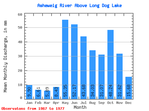
| Statistic | Jan | Feb | Mar | Apr | May | Jun | Jul | Aug | Sep | Oct | Nov | Dec | Annual |
|---|---|---|---|---|---|---|---|---|---|---|---|---|---|
| Mean | 9.90 | 6.67 | 5.89 | 8.43 | 55.34 | 52.17 | 43.67 | 34.03 | 31.07 | 48.23 | 31.62 | 15.68 | 343.11 |
| Standard Deviation | 2.61 | 1.21 | 1.20 | 4.48 | 28.23 | 33.05 | 18.64 | 20.35 | 13.65 | 31.19 | 16.38 | 5.94 | 64.30 |
| Min | 6.07 | 4.80 | 3.85 | 3.94 | 19.42 | 20.72 | 21.66 | 18.60 | 11.76 | 9.75 | 8.32 | 6.95 | 231.99 |
| Max | 15.13 | 8.89 | 8.51 | 15.68 | 115.72 | 135.20 | 71.41 | 83.48 | 54.64 | 114.06 | 64.88 | 28.35 | 406.03 |
| Coefficient of Variation | 0.26 | 0.18 | 0.20 | 0.53 | 0.51 | 0.63 | 0.43 | 0.60 | 0.44 | 0.65 | 0.52 | 0.38 | 0.19 |
 Return to R-Arctic Net Home Page