|
|
|||||||||||||||||
| Point ID: 4329 | Downloads | Plots | Site Data | Code: 04DB002 |
|
|
|||||||||||||||||
| Download | |
|---|---|
| Site Descriptor Information | Site Time Series Data |
| Link to all available data | |
| View: | Time Series | All |
| Units: | mm |
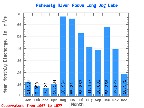
| Statistic | Jan | Feb | Mar | Apr | May | Jun | Jul | Aug | Sep | Oct | Nov | Dec | Annual |
|---|---|---|---|---|---|---|---|---|---|---|---|---|---|
| Mean | 11.98 | 8.86 | 7.13 | 10.53 | 66.96 | 65.21 | 52.83 | 41.17 | 38.83 | 58.36 | 39.52 | 18.97 | 35.22 |
| Standard Deviation | 3.16 | 1.61 | 1.45 | 5.60 | 34.15 | 41.32 | 22.55 | 24.61 | 17.06 | 37.74 | 20.48 | 7.19 | 6.60 |
| Min | 7.34 | 6.37 | 4.66 | 4.92 | 23.50 | 25.90 | 26.20 | 22.50 | 14.70 | 11.80 | 10.40 | 8.41 | 23.82 |
| Max | 18.30 | 11.80 | 10.30 | 19.60 | 140.00 | 169.00 | 86.40 | 101.00 | 68.30 | 138.00 | 81.10 | 34.30 | 41.68 |
| Coefficient of Variation | 0.26 | 0.18 | 0.20 | 0.53 | 0.51 | 0.63 | 0.43 | 0.60 | 0.44 | 0.65 | 0.52 | 0.38 | 0.19 |
 Return to R-Arctic Net Home Page