|
|
|||||||||||||||||
| Point ID: 4327 | Downloads | Plots | Site Data | Code: 04DA002 |
|
|
|||||||||||||||||
| Download | |
|---|---|
| Site Descriptor Information | Site Time Series Data |
| Link to all available data | |
| View: | Time Series | All |
| Units: | m3/s |
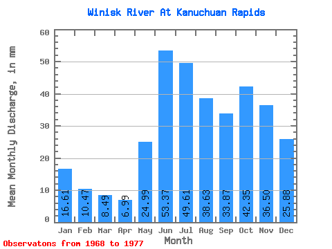
| Statistic | Jan | Feb | Mar | Apr | May | Jun | Jul | Aug | Sep | Oct | Nov | Dec | Annual |
|---|---|---|---|---|---|---|---|---|---|---|---|---|---|
| Mean | 16.61 | 10.56 | 8.49 | 6.99 | 24.99 | 53.37 | 49.60 | 38.62 | 33.87 | 42.34 | 36.50 | 25.88 | 359.28 |
| Standard Deviation | 5.50 | 2.55 | 1.51 | 1.16 | 13.09 | 16.57 | 19.28 | 12.00 | 12.78 | 24.39 | 15.66 | 8.82 | 81.53 |
| Min | 8.15 | 6.11 | 5.83 | 5.48 | 11.39 | 30.42 | 20.72 | 15.50 | 13.45 | 12.62 | 11.06 | 9.51 | 204.31 |
| Max | 25.09 | 13.61 | 10.42 | 9.81 | 58.77 | 88.95 | 83.58 | 50.60 | 51.84 | 94.29 | 55.52 | 37.63 | 480.10 |
| Coefficient of Variation | 0.33 | 0.24 | 0.18 | 0.17 | 0.52 | 0.31 | 0.39 | 0.31 | 0.38 | 0.58 | 0.43 | 0.34 | 0.23 |
 Return to R-Arctic Net Home Page