|
|
|||||||||||||||||
| Point ID: 4327 | Downloads | Plots | Site Data | Code: 04DA002 |
|
|
|||||||||||||||||
| Download | |
|---|---|
| Site Descriptor Information | Site Time Series Data |
| Link to all available data | |
| View: | Time Series | All |
| Units: | mm |
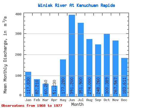
| Statistic | Jan | Feb | Mar | Apr | May | Jun | Jul | Aug | Sep | Oct | Nov | Dec | Annual |
|---|---|---|---|---|---|---|---|---|---|---|---|---|---|
| Mean | 117.83 | 82.21 | 60.26 | 51.23 | 177.28 | 391.20 | 351.90 | 274.00 | 248.26 | 300.39 | 267.57 | 183.61 | 216.29 |
| Standard Deviation | 39.01 | 19.85 | 10.73 | 8.53 | 92.84 | 121.47 | 136.78 | 85.14 | 93.70 | 173.05 | 114.80 | 62.60 | 49.08 |
| Min | 57.80 | 47.60 | 41.40 | 40.20 | 80.80 | 223.00 | 147.00 | 110.00 | 98.60 | 89.50 | 81.10 | 67.50 | 123.00 |
| Max | 178.00 | 106.00 | 73.90 | 71.90 | 417.00 | 652.00 | 593.00 | 359.00 | 380.00 | 669.00 | 407.00 | 267.00 | 289.03 |
| Coefficient of Variation | 0.33 | 0.24 | 0.18 | 0.17 | 0.52 | 0.31 | 0.39 | 0.31 | 0.38 | 0.58 | 0.43 | 0.34 | 0.23 |
 Return to R-Arctic Net Home Page