|
|
|||||||||||||||||
| Point ID: 4324 | Downloads | Plots | Site Data | Code: 04CD002 |
|
|
|||||||||||||||||
| Download | |
|---|---|
| Site Descriptor Information | Site Time Series Data |
| Link to all available data | |
| View: | Time Series | All |
| Units: | m3/s |
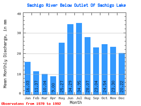
| Statistic | Jan | Feb | Mar | Apr | May | Jun | Jul | Aug | Sep | Oct | Nov | Dec | Annual |
|---|---|---|---|---|---|---|---|---|---|---|---|---|---|
| Mean | 16.03 | 11.47 | 10.04 | 9.00 | 25.27 | 34.29 | 34.95 | 28.07 | 23.04 | 24.54 | 23.30 | 20.21 | 255.07 |
| Standard Deviation | 3.58 | 2.40 | 1.99 | 1.83 | 9.21 | 13.66 | 18.45 | 12.22 | 8.67 | 7.65 | 6.74 | 4.87 | 64.57 |
| Min | 7.59 | 6.00 | 5.71 | 6.37 | 12.73 | 14.57 | 16.31 | 11.98 | 10.87 | 13.04 | 9.89 | 8.72 | 154.66 |
| Max | 24.15 | 16.40 | 14.86 | 13.96 | 46.47 | 61.31 | 74.63 | 52.56 | 42.01 | 42.52 | 42.43 | 31.86 | 367.52 |
| Coefficient of Variation | 0.22 | 0.21 | 0.20 | 0.20 | 0.36 | 0.40 | 0.53 | 0.43 | 0.38 | 0.31 | 0.29 | 0.24 | 0.25 |
 Return to R-Arctic Net Home Page