|
|
|||||||||||||||||
| Point ID: 4324 | Downloads | Plots | Site Data | Code: 04CD002 |
|
|
|||||||||||||||||
| Download | |
|---|---|
| Site Descriptor Information | Site Time Series Data |
| Link to all available data | |
| View: | Time Series | All |
| Units: | mm |
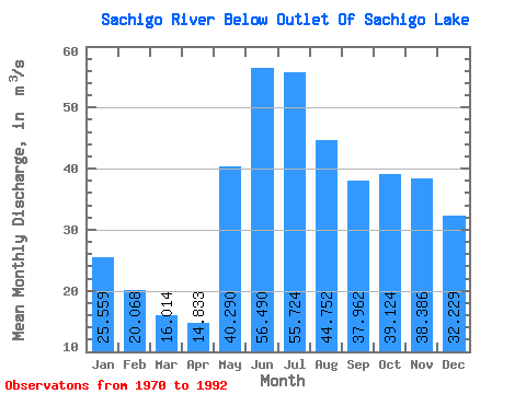
| Statistic | Jan | Feb | Mar | Apr | May | Jun | Jul | Aug | Sep | Oct | Nov | Dec | Annual |
|---|---|---|---|---|---|---|---|---|---|---|---|---|---|
| Mean | 25.56 | 20.07 | 16.01 | 14.83 | 40.29 | 56.49 | 55.72 | 44.75 | 37.96 | 39.12 | 38.39 | 32.23 | 34.51 |
| Standard Deviation | 5.71 | 4.20 | 3.17 | 3.01 | 14.69 | 22.50 | 29.41 | 19.49 | 14.28 | 12.20 | 11.11 | 7.76 | 8.74 |
| Min | 12.10 | 10.50 | 9.11 | 10.50 | 20.30 | 24.00 | 26.00 | 19.10 | 17.90 | 20.80 | 16.30 | 13.90 | 20.93 |
| Max | 38.50 | 28.70 | 23.70 | 23.00 | 74.10 | 101.00 | 119.00 | 83.80 | 69.20 | 67.80 | 69.90 | 50.80 | 49.73 |
| Coefficient of Variation | 0.22 | 0.21 | 0.20 | 0.20 | 0.36 | 0.40 | 0.53 | 0.43 | 0.38 | 0.31 | 0.29 | 0.24 | 0.25 |
 Return to R-Arctic Net Home Page