|
|
|||||||||||||||||
| Point ID: 4323 | Downloads | Plots | Site Data | Code: 04CD001 |
|
|
|||||||||||||||||
| Download | |
|---|---|
| Site Descriptor Information | Site Time Series Data |
| Link to all available data | |
| View: | Time Series | All |
| Units: | m3/s |
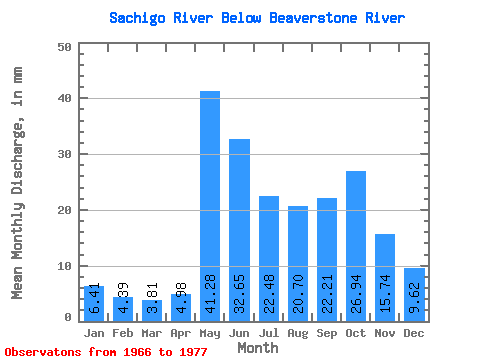
| Statistic | Jan | Feb | Mar | Apr | May | Jun | Jul | Aug | Sep | Oct | Nov | Dec | Annual |
|---|---|---|---|---|---|---|---|---|---|---|---|---|---|
| Mean | 6.41 | 4.43 | 3.81 | 4.98 | 41.27 | 32.65 | 22.47 | 20.69 | 22.21 | 26.94 | 15.74 | 9.62 | 215.77 |
| Standard Deviation | 2.24 | 1.41 | 1.16 | 2.42 | 21.94 | 18.45 | 7.72 | 10.75 | 10.31 | 12.72 | 7.58 | 3.86 | 39.84 |
| Min | 3.29 | 2.32 | 2.04 | 2.47 | 16.63 | 8.65 | 10.65 | 8.44 | 7.75 | 7.35 | 6.62 | 4.63 | 156.60 |
| Max | 10.55 | 6.87 | 5.66 | 10.48 | 89.22 | 69.53 | 34.90 | 48.10 | 43.36 | 42.01 | 31.57 | 16.75 | 286.48 |
| Coefficient of Variation | 0.35 | 0.32 | 0.30 | 0.49 | 0.53 | 0.56 | 0.34 | 0.52 | 0.46 | 0.47 | 0.48 | 0.40 | 0.18 |
 Return to R-Arctic Net Home Page