|
|
|||||||||||||||||
| Point ID: 4323 | Downloads | Plots | Site Data | Code: 04CD001 |
|
|
|||||||||||||||||
| Download | |
|---|---|
| Site Descriptor Information | Site Time Series Data |
| Link to all available data | |
| View: | Time Series | All |
| Units: | mm |
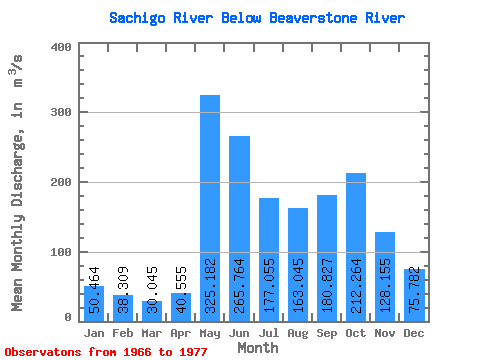
| Statistic | Jan | Feb | Mar | Apr | May | Jun | Jul | Aug | Sep | Oct | Nov | Dec | Annual |
|---|---|---|---|---|---|---|---|---|---|---|---|---|---|
| Mean | 50.46 | 38.31 | 30.05 | 40.55 | 325.18 | 265.76 | 177.06 | 163.04 | 180.83 | 212.26 | 128.16 | 75.78 | 144.25 |
| Standard Deviation | 17.63 | 12.17 | 9.11 | 19.70 | 172.85 | 150.17 | 60.85 | 84.68 | 83.96 | 100.21 | 61.69 | 30.43 | 26.64 |
| Min | 25.90 | 20.10 | 16.10 | 20.10 | 131.00 | 70.40 | 83.90 | 66.50 | 63.10 | 57.90 | 53.90 | 36.50 | 104.70 |
| Max | 83.10 | 59.40 | 44.60 | 85.30 | 703.00 | 566.00 | 275.00 | 379.00 | 353.00 | 331.00 | 257.00 | 132.00 | 191.53 |
| Coefficient of Variation | 0.35 | 0.32 | 0.30 | 0.49 | 0.53 | 0.56 | 0.34 | 0.52 | 0.46 | 0.47 | 0.48 | 0.40 | 0.18 |
 Return to R-Arctic Net Home Page