|
|
|||||||||||||||||
| Point ID: 397 | Downloads | Plots | Site Data | Code: 05CE012 |
|
|
|||||||||||||||||
| Download | |
|---|---|
| Site Descriptor Information | Site Time Series Data |
| Link to all available data | |
| View: | Time Series | All |
| Units: | m3/s |
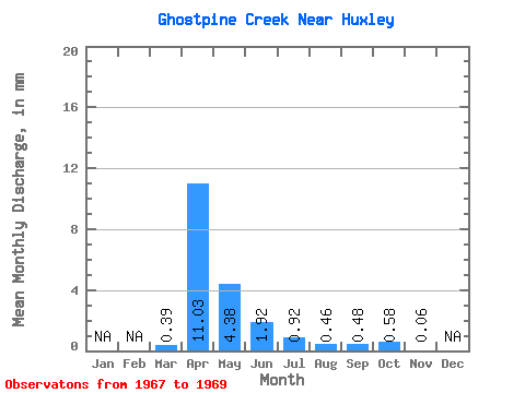
| Statistic | Jan | Feb | Mar | Apr | May | Jun | Jul | Aug | Sep | Oct | Nov | Dec | Annual |
|---|---|---|---|---|---|---|---|---|---|---|---|---|---|
| Mean | 0.29 | 8.09 | 3.21 | 1.41 | 0.67 | 0.34 | 0.36 | 0.42 | 0.04 | ||||
| Standard Deviation | 0.50 | 10.06 | 3.15 | 1.16 | 0.22 | 0.28 | 0.37 | 0.56 | |||||
| Min | 0.00 | 0.34 | 0.17 | 0.59 | 0.52 | 0.03 | 0.00 | 0.05 | 0.04 | ||||
| Max | 0.86 | 19.46 | 6.46 | 2.24 | 0.82 | 0.58 | 0.74 | 1.07 | 0.04 | ||||
| Coefficient of Variation | 1.73 | 1.24 | 0.98 | 0.82 | 0.32 | 0.85 | 1.03 | 1.32 |
 Return to R-Arctic Net Home Page