|
|
|||||||||||||||||
| Point ID: 3684 | Downloads | Plots | Site Data | Code: 10RA001 |
|
|
|||||||||||||||||
| Download | |
|---|---|
| Site Descriptor Information | Site Time Series Data |
| Link to all available data | |
| View: | Time Series | All |
| Units: | m3/s |
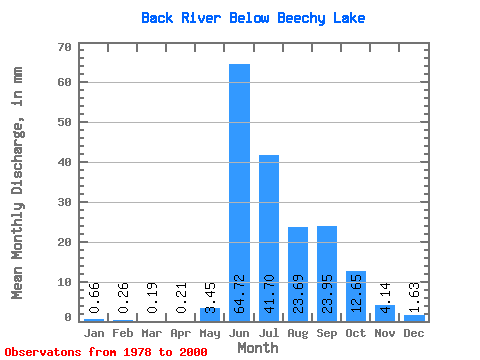
| Statistic | Jan | Feb | Mar | Apr | May | Jun | Jul | Aug | Sep | Oct | Nov | Dec | Annual |
|---|---|---|---|---|---|---|---|---|---|---|---|---|---|
| Mean | 0.66 | 0.27 | 0.19 | 0.21 | 3.45 | 64.72 | 41.70 | 23.69 | 23.95 | 12.65 | 4.14 | 1.63 | 175.23 |
| Standard Deviation | 0.74 | 0.37 | 0.26 | 0.21 | 4.18 | 32.14 | 12.63 | 6.71 | 14.04 | 5.01 | 2.71 | 1.37 | 49.37 |
| Min | 0.00 | 0.00 | 0.00 | 0.00 | 0.00 | 12.26 | 14.48 | 11.33 | 11.51 | 4.61 | 0.87 | 0.03 | 89.60 |
| Max | 2.34 | 1.05 | 0.66 | 0.55 | 12.64 | 156.05 | 59.30 | 36.34 | 73.53 | 20.91 | 9.55 | 3.62 | 286.21 |
| Coefficient of Variation | 1.13 | 1.39 | 1.39 | 0.98 | 1.21 | 0.50 | 0.30 | 0.28 | 0.59 | 0.40 | 0.65 | 0.84 | 0.28 |
 Return to R-Arctic Net Home Page